
To More Inquiry
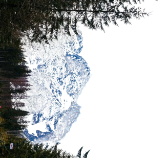
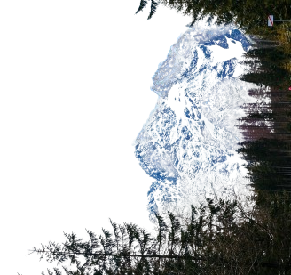
Grade:Easy Location: Uttarakhand Altitude:3856 m Duration:6 Days Resting in the depths of the Uttarakhand Himalayas, the Brahmatal trek treats you to soaring views of some lofty mountain peaks such as Mt. Trishul, Mt Nanda Ghunti and Mt. Khamet. At an altitude of 3800 m, the Brahmatal trek is open throughout the winters when most of the other trekking routes are closed making it a perfect winter trek for beginners. Brahmatal hosts one of the loveliest forest walks that are home to diverse bird species and century old oak trees. During spring, the trails of these forests are carpeted in the red and pink blooms of rhododendrons. In winters, the landscape transforms dramatically sheathing the region in pristine white snow, making it nothing short of a Winter wonderland. Spanning over 28 km, the Brahmatal trek begins from the base village of Lohajung located in the Chamoli district in Garhwal Himalayas. The 6 km trek from Lohajung to the Gujreni campsite runs through dense forests of Conifer, Cedar, Oak and Fir. The Gujreni campsite is at the heart of a beautiful clearing surrounded by Oak and Rhododendrons with panoramic views of snow-capped ranges. The next day, the trek gradient increases gradually. A 2-hour trek will lead you to the Bekaltal lake, frozen during the winter months, making up for a tranquil view. The trail heading out of the lake continues to remain dominated by Oak and Rhododendron forests. You start catching glimpses of Mt Trishul through the woods from here on. The forest soon opens up to an expansive meadow, Talindi Top, that rewards you with spectacular views of Mt. Trishul and Mt. Nanda Ghunti amongst others. The ascent continues beyond this point until you reach Jhandi Top which surpasses the views offered by Talindi Top. It is a 1.5 km descent from here onwards to the Brahmatal campsite. The campsite is delightfully set at one end of a ridge, opening up to a stunning view of the blue silhouette of mountain ranges stacked layer after layer at the horizon. The Brahmatal lake is only 500 M from the campsite. According to legend, the lake is believed to be the place where Lord Brahma meditated ages ago. The trek to the summit begins the next day and is nothing short of thrilling. The trail climbs through moderately inclined dense forests eventually translating into a ridge stretch that opens up to gaping views of the tremendous valley behind. The summit offers awe-inspiring vistas of some well-known Himalayan ranges like Mount Trishul, sacred Mount Nanda Ghunti, Mount Chaukhamba, Mount Neelkanth, Mount Kamet and Mount Hathi Ghoda.
Distance: 294 kms (Dehradun to Lohajung) Duration: 11-12 hours We begin our journey to Lohajung from ISBT Dehradun latest by 7 AM. It is located at a distance of 294 km from Dehradun and would take about 11-12 hours to cover. The landscapes throughout this drive are striking. The journey begins with a drive uphill that will take you through the Kumaon region into the Himalayan Belt of Garhwal. The roads here are extensive and the Shivalik ranges can be spotted at the horizon. The setting is tranquil and the Ganga river accompanies you swiftly throughout this stretch. It gets exciting after this. We will be passing through three of the five iconic confluences of the Alaknanda river (Devprayag, Rudraprayag and Karnaprayag) on the way to Lohajung. A beautiful showcase of tradition, Devprayag, is the first confluence we will be passing by. It is the converging point of the Bhagirathi and Alaknanda rivers. You can clearly see the turquoise of one merging with the teal of the other in the valley below. 40 kms from this point, we reach the historic town of Srinagar on the banks of Alaknanda. The Rudraprayag lies further ahead from here. It is the confluence of the Mandakini and Alaknanda rivers. About 33 km from Rudraprayag is the third confluence of Karnapraya, the meeting point of the Alaknanda and the Pindari River. Each confluence is unique in its setting and is a delight to behold! Lohajung, located in the Chamoli district of the Garhwal Himalayas, is 86 km from Karnaprayag. Expect to reach Lohajung by late evening around 8-9pm.
Distance: 6 kms Duration: 4-5 hours We begin from Lohajung at 9 AM. Packed lunches will be provided for the day. The trek starts on a well-paved stone trail that heads into the forest. The Nanda Ghunti Peak can be spotted right from the beginning of the trek. After a short walk through the woods, you will come across Mandoli village tucked in to the colossal mountain ranges on your left. The trail ascends gradually in long, serpentine curves from here. Higher up, you will be able to spot the Kali Valley which is the confluence of the Kali and Pindari rivers. Beyond this point, the trail mostly runs through dense forests of conifer, Cedar, Oak and Fir allowing little sunlight in. There are also Rhododendrons in this region. They bloom during late winter and early spring season and cover the trail in pretty colors of orange and red. During the winter months, these paths are covered with pristine white snow and no flower blossoms. The next landmark from here is a 10 m wooden bridge running over a stream where you can refill your bottles. Crossing the bridge, you will reach Begum that makes for an excellent resting point overlooking the expansive Navali and Bagdi Bugyals. At a 20 minute hike from here, you will come across two streams. The second stream which is the Gujreni stream will eventually lead you to a beautiful clearing set in the backdrop of lush forests. This is the campsite for the day. This region carries a woody scent and is surrounded by umber-brown Oak and Rhododendron forests. After setting up the camps, try spotting some of the birds around like Himalayan Woodpecker, Asian Barred Owlet and Blue-fronted Redstart amongst others. You will encounter snow from late December till Early March at this campsite dropping the temperature considerably. Rejoice in the seclusion and silence of the campsite for it offers an opportunity to look inwards as much as outwards.
Distance: 5 kms Duration: 4-5 hours The trail from the Gujreni Campsite enters a thicket of forests with a moderate ascent throughout. You will catch the first glimpse of Mt. Trishul through the towering trees here. At a 2 hour hike away, lays the Bekaltal lake lined with Oak trees all around. The color of the water is mud-brown indicating a high amount of dissolved organic matter. During the peak winter months, the lake is likely to be frozen. You can spend some time here immersing in the profound silence of this setting. The trail dives straight into dense Oak and Rhododendron forests with a steep incline for the next hour. As you walk higher, you will see an idyllic view of the Bekaltal Lake retreating slowly below. The canopy of the forests is almost impenetrable, keeping most of the sunlight out. This allows patches of snow to sustain on the trails even in early spring season. After an hour or so, the forest opens up to a spectacular meadow, called Talindi Top which offers some phenomenal views of Mt. Trishul and Mt. Nanda Ghunti. 1 km from here is the Jhandi top that sets a stunning vantage point surpassing the views offered earlier at Talindi Top. With the skies wide open and several layers of jewel-blue mountains decked one over the other, the spectacle is absolutely surreal to behold. Jhandi Top marks the highest point on the ridge. The trail begins to descend beyond this point. The Brahmatal campsite is only 1.5 km of a downhill trek on the ridge from here. After you reach the campsite, you can visit the Brahmatal Lake which is only 500m from the campsite. The Brahmatal lake is believed to be the place where Lord Brahma meditated long ago. This lake is completely frozen during winter season and is a marvel to behold. One can go out and explore the beautiful photography options available at this place. Be prepared for subzero temperatures that could fall even below -7 degree Celsius during peak winter nights.
Distance: 6 kms Duration: 4 hours The trek starts early around 6AM after having a light breakfast at the campsite. This day of the trek is the most fascinating visually and the terrain is relatively easy to negotiate. There is also the added advantage of leaving the backpacks behind at the campsite since we will be returning here for the night. During the winter season, your trek leader will provide you with microspikes and gaiters depending upon the snow conditions. 20 minutes into the trek, you will come across the Brahmatal lake tucked into the middle of a lush clearing. The trail till the Brahmatal lake is a steep incline climbing steadily through open grasslands. In the winter season, this area is usually covered in a sheath of white snow making it no less than a Winter Wonderland while the lake glistens under the morning sunshine. Beyond the lake, the trail ascends moderately and envelopes into a ridge. You will notice the Brahmatal lake retiring in the valley below as you steadily gain altitude. The first ridge is a stretch of gentle ascent that leads you to the final ridge climb. The final ridge eventually opens up tp a breath-taking spectacle of snow-capped mountain ranges standing so close to you that you feel like you are watching them on a theatre screen. Try spotting Mt. Trishul, Mt. Nanda Ghunti, Mt. Chaukhamba, Mt. Neelkanth, Mt. Kamet and Mt. Hathi Ghoda amongst the ranges. Although Mt. Trishul and Mt. Nanda Ghunti accompany you throughout the trek, the close-up view from the summit is still thrilling to behold. Spend some time at the top immersing in the experience before heading back to the campsite.
Distance: 11 kms Duration: 7-8 hours After having a scrumptious breakfast, we begin the descent back to Lohajung at 8 AM following the same route as the ascent. Be prepared for a long day of trekking. The trail runs through thick Oak and Rhododendron forests. Eventually, you will come across little Shepherds huts which the locals use to keep their livestock. Following the man-made stone trail beyond that point, you will be descending to the mountain villages leading to Lohajung. Expect to reach Lohajung in about 7-8 hours. You can then explore the slow and peaceful life at the village and learn about the various legends around the area. Do not miss the sunset in the evening. The orange rays brushing the Mt. Nanda Ghunti peak gently is lovely to watch. This is followed by a piping hot dinner at the guest house.
Distance: 294 kms Duration: 11-12 hours After morning tea, we will be starting for Dehradun early at 6-7 AM. The journey will once again take you through the three confluences of Karnaprayag, Rudraprayag and Devprayag. Expect to reach ISBT Dehradun by 6-7 PM. In case, you plan on traveling back to Delhi the same night, consider booking a bus that starts at around 10-12 PM to account for any delays we might encounter on the way.
Plan ahead and lock in your perfect getaway today. Early booking ensures peace of mind, better deals, and a smooth travel experience from start to finish!
To receive our best monthly deals