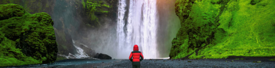
Grade:ProLocation: HimachalAltitude:6264 mDuration:16 DaysChandrabhaga range is a group of peaks located in the cold desert region of Himachal Pradesh of which a few have been climbed, a few barely so and some that are still waiting to invite climbers up their mad slopes in this mad terrain. CB13 (6,264M) holds somewhat of a star-status in this range which gets its name from the two main rivers in Lahaul – Chandra and Bhaga. A technical and a challenging climb, CB13 is one of those gems which was made more accessible after the inaugural of Atal Tunnel. The beauty of Lahaul is one of its kind which you notice as soon as you come out on the other side of the tunnel - the difference is so stark, it's unmissable! The landscape and its beauty is the very definition of raw which extends to the peaks in the region. For its peculiar terrain, the climb up the peaks in this region is one of a kind, too, since it comes with its own set of unique challenges. CB13 (6,264M) is a perfect way to experience the region as a whole. Add CB14, which at 6,078M, is the second most sought after peak in the central massif in Lahaul, to the mix and it’s only a cherry on the mountain-top. With its boulder-strewn terrain, CB14 is equally, if not more challenging than it’s almost 200M taller cousin, and calls to all the skills you might have accumulated in your years in the mountains, hitherto.As both these mountains change face every year for the receding glacier exposing more of their crumbling rock underneath, they are only getting harder to climb with each passing year. The long stretches of boulder sections continue all the way to the top of the mountains. For CB13, the last 150M to the summit literally calls for some serious rock climbing skills on the patch of rocks chest-high which run vertical and tall and CB14, with even lesser patches of snow would ultimately appeal more to the rock climber in you.From our experience, we can say that these 6000M peaks which lie across the Dhaka glacier and offer magnificent views of Kunzum Range, Chandratal and the gushing Chandra river from their summits, are quite the firecrackers for their height. With their uneven landscape and impossible slopes, they almost seem unwelcoming at first sight but they aren’t actually so - they only call for a little more patience, a fair bit of attention and a lot of mettle - you got these, and they will call for you! For their level of difficulty and the skill required to make an ascent up these mountains, and also because it is a dual climb which calls for some change in strategy for managing energy reserves on an expedition, these peaks are reserved for experienced and trained climbers only. It is essential to have some past experience in the Himalayas and high-altitude in addition to a know-how of basic mountaineering techniques for the experience to be pleasurable.If you feel strongly about dual climbs, CB13 and CB14 would be our primary recommendation for this expedition challenges all your limits and is a perfect playground to put to use all the skills you believe you possess as a mountaineer. All in all CB13 and CB14 individually are a test of one’s mettle, and together a perfect means of self-assessment of a climber, as a climber!June to October are the best months to attempt CB13 and CB14.
The trek starts from Manali, which is a very popular tourist destination as well as a high-altitude backpacking center and hence extremely accessible. Day one is reserved for everyone to make their way to Manali and get settled into their accommodation. Since climbers will be coming to this altitude from sea level, the body will need time to get comfortable with the mountain air. While the body acclimatizes, we use this time to get acquainted with each other, go over some of the basic mountain rules and discuss the route, terrain, weather and all there is to know about what to expect on CB13 and CB14.
Distance: 95 kms Duration: 5-6 hours We leave between 9 and 10 AM, after breakfast when we pick you up from the hotel. While there is no rush today since all that’s on the agenda is a 5-6 hour drive to Batal which is the trailhead for our expedition, we try to leave not-too-late for the roads in the mountains are unpredictable and it’s better to account for delays when we start. Batal is a small settlement situated in the Lahaul district of Himachal Pradesh and is also the basecamp for the infamous Chandratal Lake which is close to 14 kms from there. The drive starts along the exuberant Beas River. Within 15 minutes of the drive, we leave the crowds of the city and the smell of fuel in the air behind and get onto the Leh-Manali highway which will take us straight to the head of the Atal Tunnel. Going through this 9.02 kms long tunnel, is an experience in itself. The tunnel being at an altitude of 3,048M is the longest highway single-tube tunnel above 10,000 feet. You should reach the head of the tunnel at the mark of an hour and would take close to 10 minutes to cross this all-weather engineering marvel. Once we exit the tunnel, we are now along the murky Chinab River. The roads are characteristic of mountain roads with all its sharp turns on smooth surfaces. Right after we cross the tunnel, we begin to see a stark difference in the landscape. The trees have now shrunk to bushes, the valley is a bit more open and desolate. There are larger expanses of barren mountain-faces and grazing trails with the heavily forested mountains now nowhere in sight. What we do see in abundance though, are massive waterfalls along the way. The three major checkpoints on the way to Batal are Koksar, Gramphu and Chhatru where small dhabas are aplenty for your mid-journey cravings and snacking needs. It should take us two hours to reach Gramphu which at 3,000M is close to half way to our destination for today. The roads from here on get tricky as we take the smaller, kachcha road to our left that goes towards Spiti. As smooth as the ride was up until now, it is all rocks, boulders and dust from here – the ultimate off-road experience with crazy nallas along the way which the drivers in the region cross with some superhero-level confidence. This road is said to be one of the riskiest to drive through. We cross hoards of wild horses in the landscape opposite the road and plenty cattle playing in the numerous waterfalls along the way. At the three hour mark, we hit a patch of long hairpin bends with a constant view of the roads mimicking the meandering river ahead, the roads almost like scribble lines on dry mountains, going in no specific direction, following no specific path. At the end of this section, we reach Chhatru which is at 3,200M. From here, Batal is a 2-3 hour drive. Expect to reach by early evening post which we set up the base camp which will be our home for quite a few nights on this expedition. The location is gorgeous to say the least – there is nothing much to do in the dry wilderness of Batal except soak in the scenic beauty of the place, listen to the sound of the winds bump into the mountains and gaze at the doings of the endless groups of horses and cattle by the evening. It’s so beautiful, even the pigeons look good in this setting! Since we have already gained quite a bit of altitude for one day, do remember to keep yourself covered with appropriate layering for even though the sun here is harsh and it may feel warm, the wind at this altitude can do much damage. If you are looking to indulge in some exploring, do visit the much famous Chacha Chachi dhaba right across from your campsite to hear some pretty amazing stories from Chacha and Chachi and feast yourself to some delicious food.
We wake up with no rush since we spent our first night at high-altitude and do not want to stress the body too much. Today is reserved for acclimatization to the altitude since we gained quite a bit of height (2,000M) the previous day and have also entered a much different terrain. Coming from the humid city air to the pleasant temperature of Manali to entering Lahaul, we have moved through many different climactic zones. The weather here, in Lahaul, is much drier making it harder still for the body to adapt. We will go for an acclimatization walk in the evening where we will gain close to 300-400M in altitude, but remember to stay active and spend as much time outside your tent as possible. Spending as much time exposed to this new altitude air will help the body adapt to it much better, prepping it for what’s to come in the following days.
Distance: 10 kms Duration: 7 hours The actual trek starts today. We slowly move towards the upper reaches of the mountain. We try to leave right after an early breakfast at 7AM because it is likely to be a long day. There is a height gain of 450M and the weight on the back makes it seem much harder than it is. The terrain is mostly rocks and dust with tufts of the leftover greens you will see for a long time to come. It is good practice for the boulder-strewn terrain we are about to enter in the coming days. Watch your step for it is very easy to twist your ankle on these rocky trails. We start out traversing comfortably on the edge of the mountain face on sketched out trails as we make blind turns to discover the next mountain we are about to cross. For how dusty these regions are, it would be a good idea to cover your mouth and nose in case you have a dust allergy. To get to the basecamp, we walk alongside the murky Chandra river for the most part. One of the major challenges of getting to the basecamp is crossing the pagal nalla. There are multiple streams we need to cross within the first two hours of the day. The water level in some of the streams is so high that you are required to take off your shoes, wear them around your neck, roll up your pants and wade through the gushing and cold water with a rocky seabed not helping the crossover at all. These water crossings are also one reason that we need to leave early in the morning because the water levels rise significantly after 12 in the afternoon making it much harder to go through them. We get to these streams within the first half hour of the hike. Once out of this section, we are now alongside the river (Chandra) taking as many smooth turns as the river does, on a rocky terrain. An hour and a half of starting our day, we make it to a vast open section with wild horses curiously watching us go by with mountains in your peripheral vision in all directions. A couple of minutes and the valley gets narrower and closes up again. After 6 kms and a the mark of 3 hours into our day, we reach another vast opening at the altitude of 4000M, this time one which is green and full of yellow flowers. After having spent the last few hours on boulders in bone dry terrain, this is sure a welcome change of landscape and a perfect spot to have our packed lunch for this beauty of a land also has a water source (which you will have to hunt for, mind you!). Rest as much as you can because the next challenge for the day awaits you. Right after this grand opening, we are making a steep ascent of 300M straight. This slope eases out a bit and continues on for another 150M. Till 4,400M, it’s a climb up a green, rocky path after which it is all boulders. This continues on until we enter the last kilometer of our hike today which is mostly downhill and through rocks. Expect to reach the campsite which lies next to the river latest by early evening. The base camp is all rocks with crumbling mountains on all four sides – do not be alarmed if you hear loud thundering sounds – that is only normal here with all the rocks falling from all the sides. Every area around the base camp is rock fall area!
The day starts with a puja. The base camp for CB13 has two small stone structures brightened by the colours of the prayer flags fluttering in the mighty winds, where we offer our prayers to the mountain gods and thank them for allowing us to be there. This sacred ritual where the team members, together, seek blessings for the safety and the success of the team ends with a sip of some brandy and some sweets to fill you with warmth along with the benedictions of the mountain. A lot is to be achieved during our time at base camp. From the distribution and setting up of all the gear to technical training and practice of some basic techniques to better handle the odd terrain of CB13 and CB14. But before then, we have the entire day to rest our bodies and acclimatize to the terrain, altitude and temperature of the base camp which lies at 4,440M – a height gain of approximately 2,500M from Manali.
Since the conditions on high-altitude are unpredictable, there is a constant readjustment of plans to adapt to the situation at the time. Providing fixed day-wise schedules is hence tricky. But roughly, the schedule includes rotation rounds between camps which is a standard acclimatization process on high-altitude expeditions. An estimation of each day is as indicated below, but this is subject to change as per conditions. CB13 and CB14 share a common Advance Base Camp at 4,860M. After ABC, there is one more camp, Summit Camp at 5,650M, for CB13 whereas CB14 is attempted from ABC (4,860M) itself. Base Camp (4,440M) to Advance Base Camp (4,900M): Load ferry and occupy: Distance and duration for load ferry: 7 kms and 6-7 hours Distance and duration to occupy ABC: 3.5 kms and 4-5 hours We make two rounds between Base Camp and Advance Base Camp – the first one to ferry our load and leave it at ABC to come back down to BC for the night. The next day, we go back up to ABC, this time to move camp. Till the BC we have mules to carry the common luggage like ration, butanes, tents, sleeping bags, mattresses and all our equipment. Nature of the terrain and the altitude prevents mules from going beyond BC and hence all the (common + personal) equipment and supplies must be divided between each member of the team to be taken to the next camp. Two rounds also help divide the weight between two days which comes to approximately 15 kgs per person. The boulder-heavy glacial terrain makes for a much harder climb with all that weight on your back but it gets easier the second time around. The entire route is on glacial moraine with no trails or marked routes. It is easy to get confused and lost here, so try to stick close together. Also be wary of black ice which will not always be visible to the eye but is extremely slippery. The last 200M is the most precarious and the most exhausting as it is an extremely steep climb over loose and crumbling rocks which provide for no sure footing at all. The river fall next to this steep climb also makes certain sections of the climb slippery with the water having turned the rocks smooth taking away from their grip. This last 200M takes close to 2 hours to get through. Once on top, the campsite lies just to the left from where we also get our very first glimpse of the two mountains we are going to climb. The first and unobstructed view of both thee peaks standing next to each other is magical. Advance Base Camp (4,900M) to Summit Camp (5,650M): Distance: 2.5 kms Duration: 7-8 hours We go straight from the camp towards CB13 and start to walk up its face – the slope starts out with snow and quickly shifts to rocks and boulders after 20M. The distance between these camps is not massive but the odd and treacherous terrain makes this a long and exhausting day. At the mark of one and a half kilometers and a height gain of 250M on a bed of rocks, we reach a massive snow field with the scattered remains of the army airplane that crashed on the mountain in 1968. It is quite unnerving to imagine the events from the time of the crash as all its remnants lie right in front of you as scattered pieces of a story in the most telling condition. From here on, things are only going to get harder. Once across this snow field, we rope up and put on our crampons as we start our ascent on the 60 degree slope. What makes this section really hard are the hidden crevasses scattered across the mountain’s face like landmines and the soft snow which does little to hold your weight. Once past this section, we reach yet another slope – this one alternating between rock and snow. This section is much more precarious and needs a fixed rope. It will be traversed using a jumar. Summit Camp lies at the end of the fixed rope section at the altitude of 5,650M. The ease or difficulty of the climb between ABC and Summit Camp solely depends on the condition of the snow at the time and the weather which is known to turn from sunny to cloudy to it leading to snowfall and hail storms within seconds. Summit Camp of CB13 (5,650M) to Summit of CB13 (6,264M): We leave for the summit push anywhere between 12 and 1 AM. The approximately 650M of ascent is a constant shift between rock and snow and will be traversed using a fixed rope all the way through. It is a continuous and steep ascent and takes anywhere between 8-10 hours, one way, depending on the condition of the snow at the time. The last 150M to the summit is the most daunting and calls for actual rock climbing skills. The vertical patch of high rocks takes close to 2 hours to climb – one climber at the time must ascent on this section since it is an accident prone area with loose rocks getting knocked down with each step up, the dislodged rocks likely to hit the climber behind. With the terrain being dry and rocky, the entire route to the summit is prone to rock fall from all directions – it serves well to be highly cautious at all times. Return to ABC (4,900M): The climb down from Summit to Summit Camp should take anywhere between 6-8 hours. Depending on the condition of the team, it can be decided if the descent to ABC is to be made on the same day or after a night of rest at Summit Camp. CB13 and CB14 share the same Advance Base Camp. After a day of rest, this is where we make our summit push for CB14 from. ABC (4,900M) to CB14 (6,078M): The difficulty and duration of this climb will solely depend on the snow and weather conditions at the time.
In case of bad weather or other difficulties, Day 12 and 13 are reserved for a second summit attempt – one reserve day for each peak. These will only get used if unexpected and unforeseeable conditions present themselves at the last minute preventing the first summit push on either of the peaks in the expedition.
Distance: 3.5-4 kms Duration: 2.5-3.5 hours We trace our steps back to Base Camp after both the expeditions are over – the same route as we climbed up.
We trace our steps back to Batal through the same route we took to get here. Try to leave early so as to cross the pagal nallah in time before it gets flooded. Given the distance between BC and Batal, we camp out at Batal before pushing off for Manali the next day.
Distance: 95 kms Duration: 5-6 hours Expect to reach Manali by evening. It is recommended that you plan your journey forward the next day in case of any unforeseeable delays en route.
Plan ahead and lock in your perfect getaway today. Early booking ensures peace of mind, better deals, and a smooth travel experience from start to finish!