
To More Inquiry
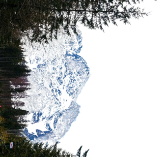
Grade:Pro Location: Himachal Altitude:6001 m Duration:15 Days Mt. Deo Tibba, at an impressive height of 6,001M, is the second highest peak of the Pir Panjal range in Kullu valley of Himachal Pradesh. Lying to the southeast of Manali above Jagatsukh village, locals consider Deo Tibba to be the point of assembly for all gods (devtas) who are believed to come together and sit on top of this peak to discuss matters of utmost importance! Legends aside, personally, it's on our list of favorites because it’s eccentric. The only word befitting for its unpredictable personality is ‘temperamental’. It is not its ever changing moods that make it eccentric but the fact that each of its moods are at a level of extreme! Starting from the backpacker’s hub that is Manali, the climb qualifies as a serious mountaineering expedition with two vertical ice gullies and an ice cap on the way to the summit. The route to the base camp of this magnificent peak takes you through the most gorgeous terrain of massive meadows with the most beautiful spread of colorful wild flowers, a panoramic view of the entire range of mountains and the clouds putting on a dramatic show all throughout the trail. As the vegetation starts to thin out, we enter a landscape of rocks, moraine and the slowly appearing snow which completely takes over the entire surface of the mountain in no time. One of the most fascinating (and challenging) parts of the climb is the daunting slope to Duhangan Col. The reputation of the col precedes it. If you've heard the stories about the col, it IS truly as intimidating as they make it sound. The other fascinating thing about Mt. Deo Tibba is its dome shaped summit which is not a sharp, singular point of the mountain which can be called the highest but a flat, more plateau like dome of ice which distinguishes it from other mountains! There are sections on the climb which require technical know-how for they involve navigating vertical ice gullies. These 60-70 degree gradients require the use of fixed ropes and certain mountaineering equipment to get through. Due to its challenging terrain and expedition style climb, Mt. Deo Tibba expedition is meant for experienced trekkers with prior knowledge of mountaineering techniques such as the use of ice axes, crampons, descender, jumar and roping up procedures. This expedition is perfect for any aspiring mountaineer intending to reach the height of 6000M+ and aiming to go up higher in the near future.
The trek starts from the town of Manali which is a very popular tourist destination and hence extremely accessible. Day one is reserved for the participants to make their way into Manali and get settled into their accommodation in a Manali hotel. First half of the day is to get comfortable with the mountain air and each other. While the body acclimatizes, we take this time to get together with the group and delve into the happenings of the next few days - schedule, what to expect, basic do's and don'ts in the mountains, how to maintain the sanctity of the environment and such matters of importance.
We will spend a day in Manali to acclimatize the body to the altitude before heading on. Use this day to go over your packing list and buy gears and clothing that you might be missing. It is a good idea to move around the town in order to acclimatize your body better – so go out and explore the ins and outs of this small mountain town which has much to offer. We also use this day to test out personal equipment like trying out snow boots for the right size and getting our crampons ready. This is essential for the right equipment is the deciding factor between success and failure of your expedition.
Distance: 20 kms + 4 kms Duration: 1 hour drive + 2 hours trek There’s no rush to leave today since it is a short day. We will be making our way to the large pastures of Chikka. To get there, we will need to drive up to the trail head – Khanol – which houses the Duhangan Hydro Project. The road to get to Khanol is not the best – you might want to eat light before the drive! It takes you in circles up 40 hairpin bends on loopy, kachcha, uneven mountain roads all the way till Khanol where all the expedition essentials will be loaded on mules. When the loopy road turns wavy, know that your drive is about to end. The trek from Khanol to Chikka is a short and pleasant walk along the Jagatsukh Nala through forested land all the way up to the open ground of Chikka. Starting off by crossing a bridge over to the other side of the nala and patches through forested land, the trek to Chikka is mostly on flat terrain with a gradual incline and magnificent views in the background. The roughly marked trail which is easy to lose is a fair indication to the fact that the region does not receive a lot of footfall and is relatively raw as compared to other more popular trekking trails. Rife with fog, an assortment of fauna and random waterfalls that suddenly make an appearance along the trail, this trek is a walk in the park. The campsite is on the open pastoral land of Chikka, next to the noisy Jagatsukh Nala.
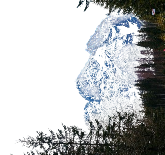
Distance: 9 kms Duration: 5 hours trek We leave early after an early breakfast today, latest by 9 AM. We continue alongside the Jagatsukh Nala. The day’s trek starts with gradual ascent under the canopy of a thick forested land for the first one hour. After an hour, the forests starts to thin out to give way to Birch trees and finally some bushes and high altitude grasslands. You will be welcomed into the grasslands carpeted with the brightest wildflowers you will see! With a few patches of old snow and a few patches of boulders, the ascent up from 3,175M to 3,700M is gradual – a little steep for the few hours the gradient starts to go down after the 3rd hour going down further at the end of the fourth hour with the land flattening out at the end of the fifth hour. The trail gets easier and the views get better due to a more open landscape. Walking alongside the nala, we pass a freshwater spring at Panduropa and Dudu Patthar until we reach the expansive grasslands at Seri with the Tainta cliffs towering to the left and the waterfalls crashing on the rocks below. We cross the zigzagging river twice to get to our campsite for the day. Remember to not let your shoes get wet while crossing the overzealous nala – remove them and hang them around your neck if that’s what it takes to keep them dry! We camp on the flatlands for the night with a massive waterfall right opposite the campsite. We go for a one hour acclimatization walk in the early evening to get used to this new height. This is when we will see the dome of Deo Tibba for the first time.
Distance: 4 kms Duration: 4-5 hours We leave between 9 and 10 AM to continue our walk on the flat meadows of Seri followed by a stream crossing. We then start our climb up a 200M steep serpentine trail which zigzags up through grasslands with patches of big boulders eventually getting to a moraine field. There is one small patch of glacier crossing on the serpentine trail which can get slippery and may require extreme caution. The vegetation starts to thin out and now turns to tufts of brown, dried up grass and we now enter a field alternating between rocks and patches of snow spread across its floor. The last one hour to get to the campsite is on an almost flat land with not much of an incline. The campsite will be chosen based on the amount of snow in the season and availability of a water source nearby. As you explore around the campsite you will realize that the dome of Deo Tibba is right opposite from you and the site also aesthetic views of Jagatsukh Peak as a bonus. We go for an acclimatization walk in the evening.
Today is reserved for acclimatization to the altitude since we gained quite a bit of height in the last few days and have also entered a much different terrain. We will also use the day to go to nearby slopes and practice our climbing techniques and get comfortable with our mountaineering equipment in the actual terrain in which we will be using them. So there are two things on the agenda for today – disbursement of personal equipment and ration that each person will be carrying in their sacks and second is to test out and practice with all the gear on actual slopes. We will also be doing a small prayer at the base camp today praying to the mountain gods for a safe and successful summit. There is a small high-altitude lake named Chota Chandratal which is an hour’s hike away from the Base Camp. If the weather permits, it is quite a rewarding place to trek to for today’s acclimatization walk.
Since the conditions on high-altitude are unpredictable, there is a constant readjustment of plans to adapt to the situation at the time. Providing fixed day-wise schedules is thence tricky. Mt. Deo Tibba has 2 camps between base camp and the summit: Camp 1(5,100M), and Summit Camp (5,500M). After the acclimatization routine suited to the conditions at the time and based on the rope fixing schedule as allowed by the weather, we occupy Summit Camp on Day 10, and will make our first summit attempt on Day 11. By Day 12, we aim to descend back down to Base Camp with an aim to depart from Manali by Day 13. Base Camp (4,480M) to Camp 1 (5,100M): Camp 1 is at Duhangan Col and should take between 6-7 hours to get to. The route from Base Camp to Camp 1 starts on 30 degree slopes with a gradual incline to get to crampon point. Three and a half hours later, we reach the most difficult section of the climb which is a vertical ice gully with a gradient between 60-65 degrees. This section requires the use of fixed ropes and an ascender to climb. Camp 1 lies right on top of this gully which is likely to take between 2.5 to 3 hours to cross. The thrilling bit is that there is no place on the entire gully to take a break and rest yourself, which means that it is a patch of demanding and continuous ascent. Camp 1 (5,100M) to Summit Camp (5,600M): There is yet another ice gully between Camp 1 and Summit Camp which needs to be navigated. Just as long as the one on the way to Camp 1, just as vertical and just as demanding, if not more. We hit the bottom of the gully two hours into the six hour climb to Summit Camp. We also encounter some very demanding patches of rock and a few knife ridges where the winds make it impossible to ignore your fear of falling on either side of the slippery trail. Summit Camp (5,600M) to Summit (6,001M): The 400M to the summit from summit camp seem manageable after the two vertical ice gullies we crossed on our way to get here. The route to the summit is gentle humps, with the real challenge being the increasing altitude and the thinning air. There is one section that requires roping up with the rest of the route being gentle slopes. Summit Camp (5,600M) Base Camp (4,480M): After returning from the summit push, we spend one night at Summit Camp – which is an open patch of land fully exposed to high speed winds. We head back down to Base Camp the next day which means navigating the knife ridges and the steep gullies one more time. Rappelling down this entire stretch should take us close to 5-6 hours. Expect to reach the sanctuary of your tents at Base Camp before sundown.
Distance: 18 kms + 20 kms Duration: 5-6 hours trek + 1 hour drive The last day of the trek involves tracing back our steps to where we started - from the Base Camp back to Manali through Seri and Chikka and eventually a drive back from our trailhead, Khanol. We start by 9 AM, so that we can reach a lower altitude as quickly as possible. The trek and drive included should take a couple of hours and reach us to Manali by early evening. Evening of the day is reserved for celebrating the joys and achievements of the last 12 days.
In case of bad weather or other difficulties which might set us off schedule during the course of the entire expedition, Day 14 and Day 15 are set as reserve days. These will only get used if unexpected and unforeseeable conditions present themselves at the last minute preventing us from reaching our destination as planned.
Given the technical nature of its climb, its crevasse-hidden terrain and the altitude of the peaks, this expedition is for people with a fair bit of trekking experience in the Himalayas and a fair bit of technical knowledge pertaining to mountaineering equipment. A Basic Mountaineering Course certification is recommended.
Plan ahead and lock in your perfect getaway today. Early booking ensures peace of mind, better deals, and a smooth travel experience from start to finish!
To receive our best monthly deals