
To More Inquiry
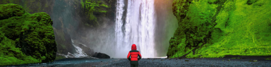
The Sar Pass Trek is one of the beautiful thrilling and adventurous trek in Parvati Valley, Sar pass is located 14,000 feet above sea level. It is one of Himachal Pradesh's most famous trek. For this Trek no prior experience is necessary. The Sar Pass trek starts from Kasol and ends at Barshaini. A 42 km Trek leads to Sar Pass in Himachal Pradesh. The trekking routes pass through pine forests, snow-covered mountains, stunning meadows, and some of the most breathtaking scenery. The Sar Pass trek allows you to discover the Himalayas' untamed and unusual flora. A sight to be noticed is pink rhododendrons painting the paths at numerous locations One of the best trek for novice trekkers is the Sar Pass trek. This is the native word for lake. Because trekker must pass via a glacier lake, this journey is called Sar, The Sar Pass trek is located near Kasol, Parvati valley. Trekkers can experience a variety of landscapes along the Sar Pass trekking trail, including woods, adorable Garahan villages, meadows, and snow-capped mountains. You can take in the beautiful vistas of the stunning snow-capped peaks on this trek. The trek officially begins in Grahan near Kasol, a town renowned for its lovely evergreen forest and mountain streams. The Sar Pass walk is rated as simple to moderate in difficulty. This walk is appropriate for families, school groups, and beginners. This Trek is simple to complete the first time. Best Time To Visit Sar Pass Trek: May through October are ideal for the Sar Pass walk because the skies are clear, and you can enjoy a breathtaking panoramic vista. The weather is erratic from October through December, and the paths will be heavily snowed. Therefore, the walk is typically not organized by companies at this time.
Report at Kasol Base Camp in the morning. After a short briefing and gear check, start trekking towards Grahan Village. The trail passes through Grahan Nallah and lush rhododendron forests. The path is easy at first but gradually becomes steep near the end. By late afternoon, reach the Grahan campsite, enjoy tea and snacks, followed by dinner. Overnight stay in tents at Grahan.
Altitude: 2,350 m to 3,400 m, Distance: 7 km, Time taken: 4-5 hours After breakfast, we will continue our 7-hour trip from Grahan to Ming Thach (our next campsite). The residents typically transport their animals to higher pastures along the trail to Ming Thach. The route has various plants and animals, including birds, insects, etc. The trail gets steeper and enters the trees as we climb higher. A meadow-like area of land is accessible from the forest's trail. The flat rocks surround the mound on which the Min Thach is situated. This camp has beautiful sunrises and sunsets.
Altitude: 3,400 m to 3,800 m, Distance: 8 km, Time taken: 4-6 hours We will continue our hike to Nagaru after an early breakfast. The route to Nagaru is moderately challenging and time-consuming as it ascends through pastoral woodlands to snow-covered meadows. As you climb higher, the air gets thinner, and you may experience mild symptoms of altitude sickness, such as headache and lightheadedness. Do as instructed by your trek leader or guide, and continue to drink enough fluids to prevent AMS. Heights. Due to the blustery winds, it is the coldest campsite of the entire walk. At night, the temperature might fall below zero. One would enjoy breathtaking views of majestic mountains across the Parvati Valley once they arrived at the Nagaru campground. At this lovely campsite, take in the sunset's colorful painting of the sky and the starry night.
Altitude: 3800-4200-3350 meters above sea level, Distance: 14 km, Time taken: 6-8 hours The longest and most important day of the Sar Pass Trek is today. We will begin our uphill, snow-covered walk after an early-morning breakfast. The trail is easy after ascending the Nagaru Ridge. A breathtaking view of Parvati valley's lovely meadows and soaring hills may be had by climbing higher to the pass. When you reach the summit of the Sar Pass, you can enjoy the delight of seeing the trail below and the impressive snow-capped peaks of the Himalayas. One might take their picnic lunch and spend some time at the Sar Pass snapping pictures. The most excellent part of this walk is a terrific slope that is perfect for sliding after the pass and takes one a kilometer far in a matter of minutes. After that, continue your hike till you reach Bishkeri Thach by descending on softer slopes through rhododendron woods. The lush green meadows, wildflowers, and variety of birds at Bishkeri can re-energize your body and mind after a long, exhausting day. You will spend the night at the Bishkeri campground.
Altitude: 3,350 m to 2,400 m, Distance: 10 km, Time taken: 4-5 hours After breakfast, trek downhill through lush pine forests, alpine meadows, and pass the twin villages of Pulga and Tulga. Cross the Parvati River to reach Barshaini, the end of the trek. From here, drive back to Kasol at your own pace and celebrate your achievement.

I had an amazing experience doing the Sar Pass Trek with HimExped. The entire trek was very well organized, and the team made sure everyone felt comfortable and safe throughout the journey. The trek leaders were friendly, experienced, and always motivating the group, especially during the tougher stretches. They regularly checked on everyone and made sure no one was left behind. Their knowledge about the mountains and the route added a lot to the experience. The campsites were beautiful, and waking up to views of snow-covered peaks and peaceful valleys was unforgettable. The food during the trek was also very good, which was a pleasant surprise considering we were in the mountains. The support staff worked really hard to make sure everything ran smoothly. The Sar Pass summit day and the snow slide were definitely the highlights of the trek. It was thrilling and something I will remember for a long time. Overall, HimExped did a fantastic job managing the trek. I would highly recommend them to anyone looking to do the Sar Pass Trek. It was truly a memorable adventure!
My Sar Pass Trek with HimExped was truly a memorable adventure. Everything was managed very professionally, and the team made the whole experience enjoyable and stress-free. The trek leaders were very supportive and ensured that everyone in the group was comfortable and safe. They kept the group motivated, shared useful trekking tips, and were always ready to help whenever someone faced difficulty on the trail. The campsites were set up at beautiful locations, surrounded by stunning mountain views and peaceful landscapes. One thing I really appreciated was the quality of food during the trek — it was fresh, tasty, and gave us the energy we needed for long trekking days. Crossing the snowy sections and reaching Sar Pass was an unforgettable moment. The famous snow slide was definitely one of the most exciting parts of the trek. Overall, HimExped did a great job organizing the trek with good planning, supportive staff, and a friendly en
Plan ahead and lock in your perfect getaway today. Early booking ensures peace of mind, better deals, and a smooth travel experience from start to finish!
To receive our best monthly deals


Hemant Sharma,
1 Apr 2025I recently completed the Sar Pass Trek with HimExped, and it was an incredible experience from start to finish. The team was extremely professional, supportive, and well-organized throughout the journey. From the moment we arrived at the base camp in Kasol, the coordinators made sure everything was smooth and comfortable. The briefing session was clear and helpful, especially for first-time trekkers like me. The trek leaders were knowledgeable about the route, weather conditions, and safety protocols, which made the entire group feel confident and secure during the trek. One of the highlights was the hospitality during the trek. The food served at the camps was surprisingly good and nutritious, which kept everyone energized for the long trekking days. The support staff and guides were always encouraging and ready to help whenever someone needed assistance. The Sar Pass trail itself was absolutely breathtaking — from dense pine forests and beautiful meadows to snow-covered landscapes near the pass. HimExped managed the campsites well and ensured proper